Wednesday, 31 July 2024

Kalka to Dehradun, Chandigarh to Dehradun - Best Route For Road Trip, Indian Roadie Preferred Route, Best Intercity Driving Route

Best Route For Road Trip, Indian Roadie Preferred Route, Best Intercity Driving Route, Motoring Route from 

Kalka to Dehradun 
(Kalka_Dehradun), 

Kalka (HR) ---- Drive on Himalayan Expressway ---- Pinjore ---- Panchkula Toll Plaza (Chandimandir Cantonment) ----- Panchkula (Majri Chowk) (HR) ---- Drive on NH7 ---- Naraingarh (HR) ---- Kala Amb (HP) ---- Nahan bypass (HP) ---- Kolar ---- Majra ---- Paonta Sahib (HP) ---- Yamuna River Bridge (HP-UK border) ---- Keep driving on NH7 ((instead of driving on Chakrata Road) ---- Dehradun (UK) 

Distance From To: 
Kalka to Dehradun = 170 kms. 

Kalka to Panchkula = 15 kms. 
Panchkula to Naraingarh = 42 kms. 
Naraingarh to Nahan = 23 kms. 
Nahan to Paonta Sahib = 40 kms. 
Paonta Sahib to Dehradun = 50 kms. 

* Haryana_Trails 
* HimachalPradesh_Trails 
* Uttarakhand_Trails 

Note: These are user generated best routes. 

Abbreviations used: 
RA = Road Ahead.
ROR = Road on Right.
ROL = Road on Left.
NH = National Highway.
SH = State Highway.
NE = National Expressway.  

P.S: 
- Offline Driving Routes In One Page 
- Best Intercity Driving Routes  
- Skip Online Navigation Maps  
- User Generated Best Routes 
- Official Road Trip Partner 
- Official Driving Route Partner 
- Choice of all road travel and automobile lovers who are consumers of products and services, too 
. 
. 
. 
* Motoring Routes of India, Best Route For Road Trip are initiatives by Indian Roadie (India's most admired road travel and automotive forum for matured roadies) and Marketingpundit. 

P.S: Search thousands of accurate and best route options for road trips throughout India, Nepal, Bhutan in: 

(ir_brfrt_mroi) 

Toll Plaza list by MORTH

Ministry of Road Transport & Highways

FUNCTIONAL TOLL PLAZAS

Posted On: 31 JUL 2024 1:43PM by PIB Delhi

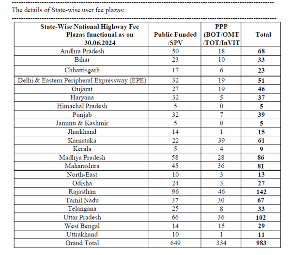
As on 30.06.2024, there are total of 983 user fee plazas functional on National Highways.

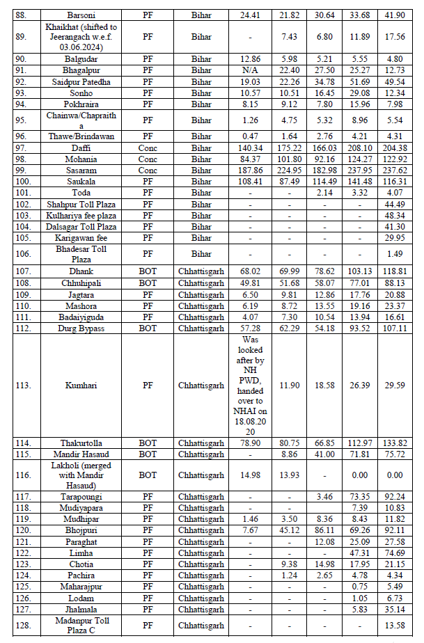
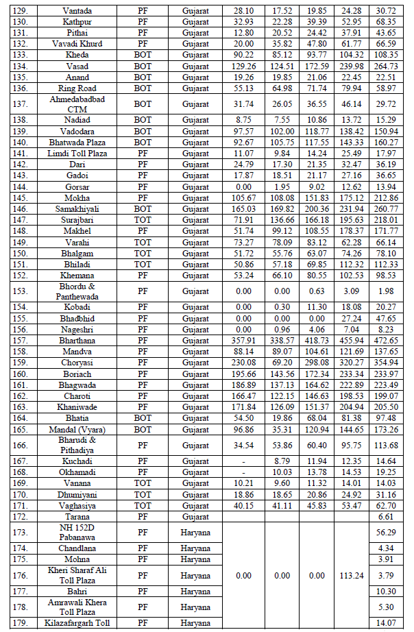
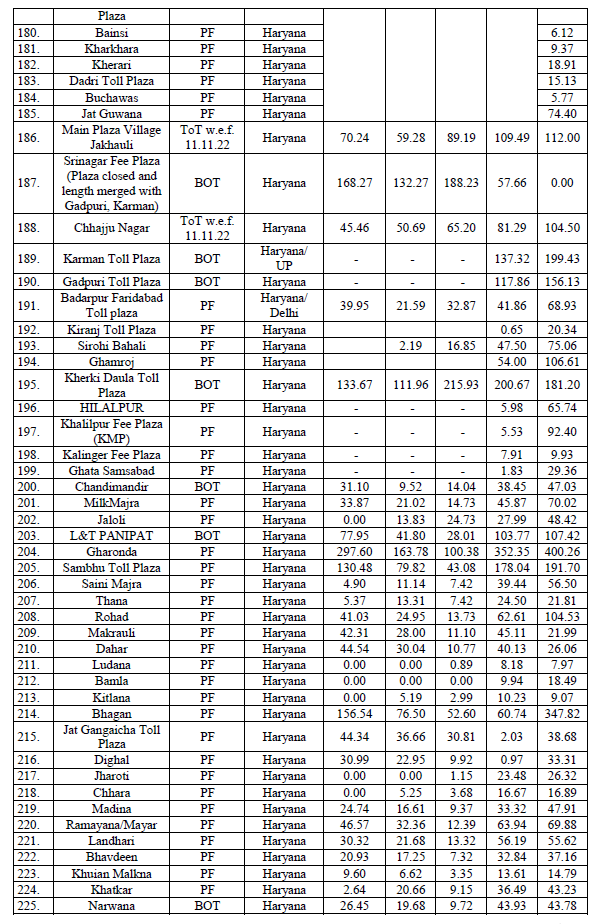
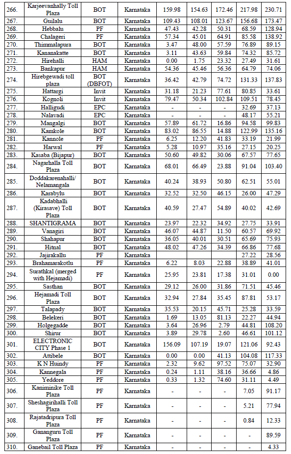
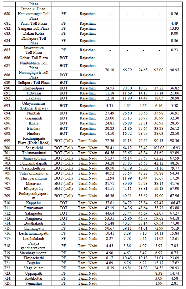
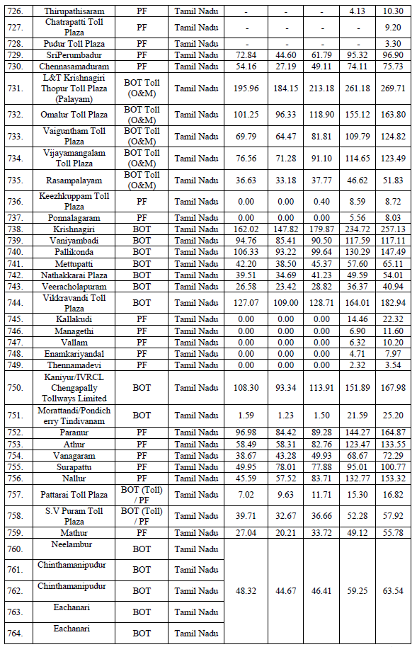
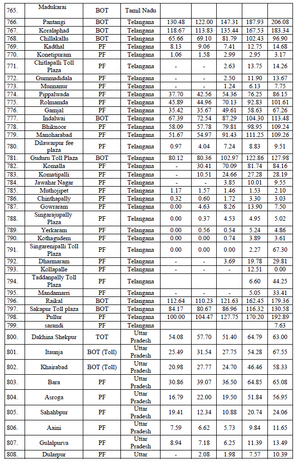
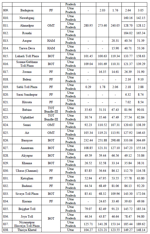
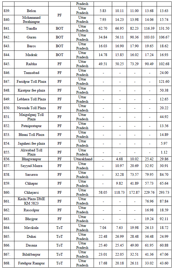
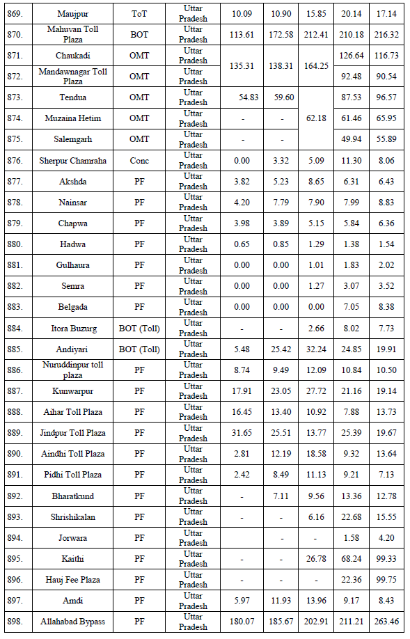
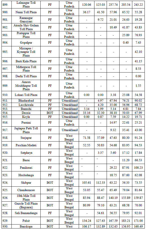
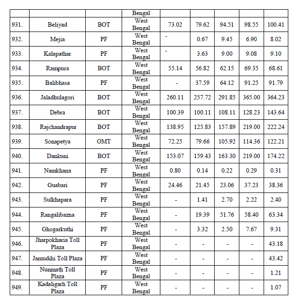
The details of State-wise user fee plazas are at Annexure A.

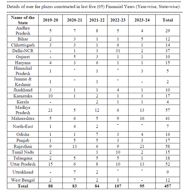
Details of user fee plazas constructed in last five (05) Financial Years (Year-wise, State-wise) are at Annexure B.

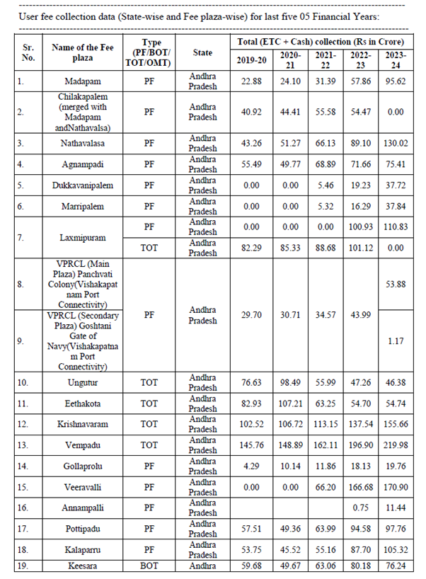
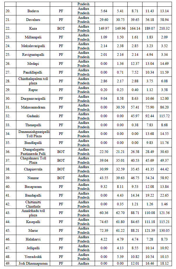
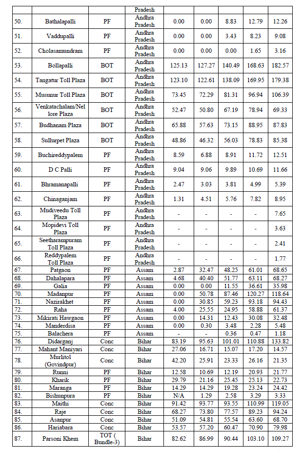
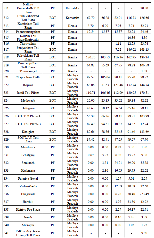
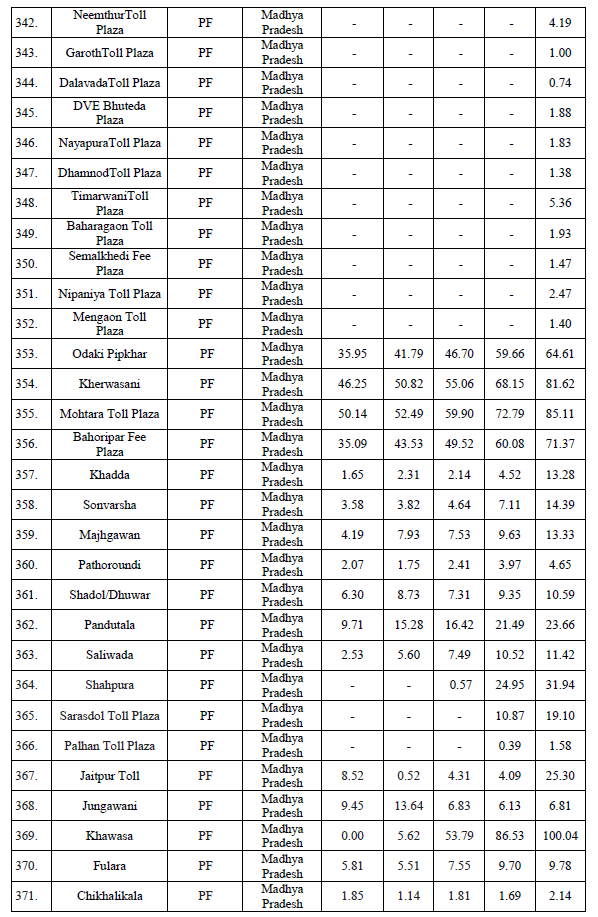
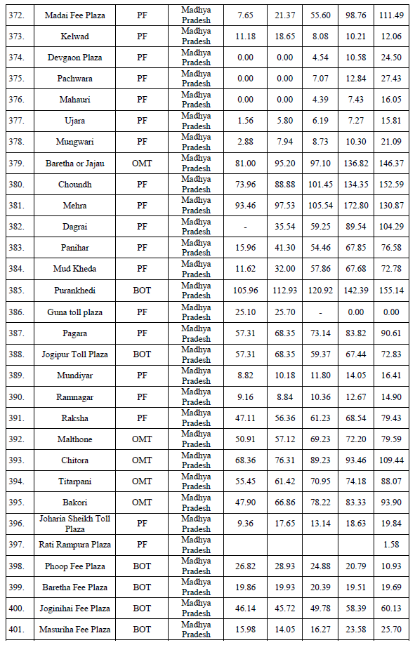
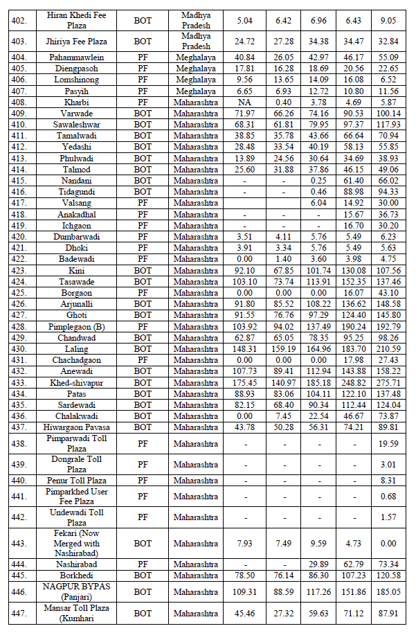
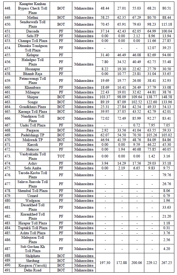
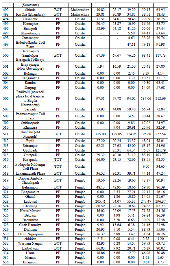
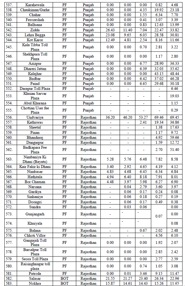
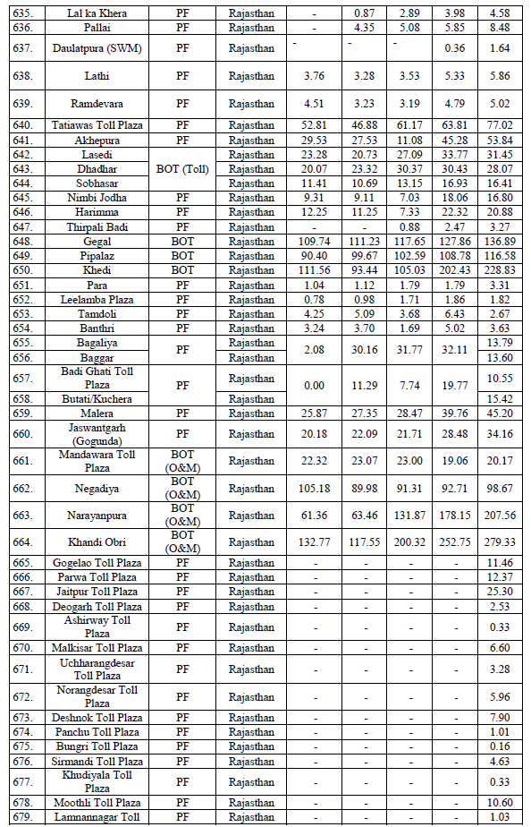
User fee collection data (State-wise and Fee plaza-wise) for last five (05) Financial Years is at Annexure C.

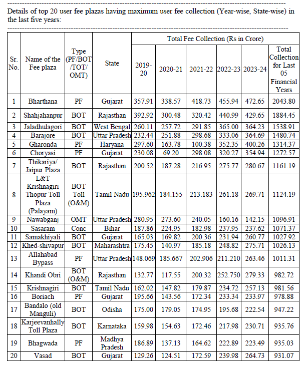
Details of top 20 fee plazas having maximum user fee collection (Year-wise, State-wise) are at Annexure D.

All National Highways fee plazas are being operated as per the applicable National Highways Fee Rules/Concession Agreement.

Annexure A

Annexure B

Annexure C

Annexure D

This information was given by the Union Minister for Road Transport and Highways, Shri Nitin Gadkari in a written reply in the Rajya Sabha today.

*****

MJPS/GS


(Release ID: 2039519) Visitor Counter : 628 


Read this release in: Hindi , Hindi_MP , Tamil

    Gwalior Fort - Must visit


    Gwalior Fort, perched majestically on a rocky hilltop in Madhya Pradesh, India, is an architectural marvel with a rich historical background. The fort's construction was initiated by Raja Suraj Sen in 773 CE, with significant contributions from various dynasties over the centuries. The architecture of Gwalior Fort showcases a blend of Rajput, Mughal, and Dravidian styles, reflecting the cultural influences that have shaped the region. 

    The fort's historical significance is immense. It has witnessed the rule of several dynasties, including the Mauryas, Sungas, Kushanas, Nagas, Guptas, and Tomars. Rao Jodha extensively constructed the fort during his reign in the 15th century, adding grand palaces and intricate carvings.  

    Visitors can explore several significant structures within its massive walls, including the Man Singh Palace, known for its blue-tiled facade and ornate rooms, and the Teli Ka Mandir, which showcases a unique blend of Dravidian and North Indian architectural styles. 

    The fort is also home to the iconic Saas Bahu Temples, dedicated to Vishnu, and the historic Gujari Mahal, now a museum displaying a remarkable collection of artifacts. The intricate rock-cut sculptures of Jain Tirthankaras on the fort's rock faces add to its historical and religious significance. 

    * Gwalior Fort 
    * MadhyaPradeshTrails 
    * Must Visit 
    * Must See

    Four laning of Talwandi Bhai to Ferozepur in PB completed


    The four-laning of 23.6 kms long Talwandi Bhai to Ferozepur section of NH5 with paved shoulder in Punjab which has already been completed, provides seamless connectivity from Ludhiana, Moga, Ferozepur up to the Hussainiwala border. 
    . 
    . 
    . 
    * Punjab Trails 
    * Indian Roadie Infrastructure Projects

    Tuesday, 30 July 2024

    How to refurbish the glass of automobile headlights


    How to refurbish the glass of automobile headlights and make it look clean as almost new. 
    . 
    . 
    . 
    * Desi jugaad 
    * DIY 
    * Indian Roadie Knowledge Hub 

    Stones fell on a vehicle during landslide near 'I Love Himachal' Park on Kalka-Shimla highway (NH5) on Monday 2024-07-29. 
    One person died on the spot and another person was seriously injured. 
    . 
    . 
    . 
    * Mishap And Calamity

    Julius Fernandes (18) died after high speed car crash in Verna, Goa in end July 2024


    Julius Fernandes (18), a resident of Loutolim, Goa lost his life after a high speed crash at Verna Industrial Estate in end July 2024. 
    He had a whole life to enjoy which he himself cut short because of his own irresponsible act. 
    . 
    . 
    . 
    * Mishap And Calamity

    Cloud burst in Tosh, HP on 2024-07-30. Leh-Manali Highway closed


    Cloud burst in Himachal's Kullu Tosh. Many bridges, shops and residential buildings washed away early in the morning on Tuesday 2024-07-30. 
    Leh-Manali Highway completely closed for vehicular traffic. 
    . 
    . 
    . 
    * Indian Roadie Road Condition 
    * Indian Roadie Weather Update 
    * Indian Roadie News

    Cycle Pagal from Balurghat, WB rode his bicycle to Amarnath, JK


    Cycle Pagal started his cycle expedition from Balurghat, Dakshin Dinajpur district, West Bengal in end May 2024 with an objective of cycling to Amarnath via Srinagar. 
    The attached video shows him cycling towards Srinagar near Ramban on NH44 in J&K in early July 2024. 
    This roadie (Indian Roadie Cyclist) deserves a salute for his perseverance.

    Vijayawada to Nirmal, Warangal to Nirmal - Best Route For Road Trip, Indian Roadie Preferred Route, Best Intercity Driving Route

    Best Route For Road Trip, Indian Roadie Preferred Route, Best Intercity Driving Route, Motoring Route from 

    Vijayawada to Nirmal 
    (Vijayawada_Nirmal), 
    Warangal to Nirmal 
    (Warangal_Nirmal), 
    Karimnagar to Nirmal 
    (Karimnagar_Nirmal), 
    Vijayawada to Warangal 
    (Vijayawada_Warangal), 
    Vijayawada to Karimnagar 
    (Vijayawada_Karimnagar): 

    Vijayawada (AP) ---- Ibrahimpatnam ---- Kodad ---- Suryapet (TS) (Exit NH65) ---- Nuthankal ---- Kuntlapally ---- Danthalapally ---- Matedu ---- Thorrur ---- Mylaram ---- Yellanda ---- Warangal (TS) ---- Hanumakonda (TS) ---- Hasanparthy Lake on left ---- Elkathurthy (TS) ---- Huzurabad ---- Kesavapatnam ---- Karimnagar (TS) ---- Jagityal/ Jagtal (TS) ---- Korutla ---- Metpally ---- Kammarpally ---- Armoor/ Armur ---- Soan Ganga Bridge over Godavari River ---- Nirmal (TS) on NH44

    Distances: 
    Vijayawada to Suryapet 
    (Vijayawada_Suryapet) = 140 kms. 
    Suryapet to Warangal 
    (Suryapet_Warangal) = 105 kms. 
    Warangal to Karimnagar 
    (Warangal_Karimnagar) = 80 kms. 
    Karimnagar to Kammarpally 
    (Karimnagar_Kammarpally) = 95 kms. 
    Kammarpally to Armur 
    (Kammarpally_Armur) = 22 kms. 
    Armur to Nirmal 
    (Armir_Nirmal) = 40 kms. 

    * Telangana Trails 

    Note: These are user generated best routes. 

    Abbreviations in use in Motoring Routes Of India, Indian Roadie Preferred Route, Motoring Route, Driving Route:
    RA = Road Ahead.
    ROR = Road on Right.
    ROL = Road on Left.
    NH = National Highway.
    SH = State Highway.
    NE = National Expressway.  

    P.S: 
    - Offline Driving Route In One Page 
    - Best Intercity Driving Routes 
    - Skip Online Navigation Maps 
    - User Generated Best Routes 
    . 
    . 
    . 
    * Motoring Routes of India, Best Route For Road Trip are initiatives by Indian Roadie (India's most admired road travel and automotive forum for matured roadies) and Marketingpundit. 

    P.S: Search thousands of accurate and best route options for road trips throughout India, Nepal, Bhutan in: 

    Car toppled on Maa Flyover in Kolkata on 2024-07-29


    A car toppled on a rain drenched Maa Flyover on Monday 2024-07-29 morning. 

    No further details are available. 
    . 
    . 
    . 
    * Mishap And Calamity

    Monday, 29 July 2024

    Jamshedpur to Rourkela - Best Route For Road Trip, Indian Roadie Preferred Route, Best Intercity Driving Route

    Indian Roadie Preferred Route, Best Route For Road Trip, Driving Route, Motoring Route, Best Intercity Driving Route from 

    Jamshedpur to Rourkela   
    (Jamshedpur_Rourkela): 

    Jamshedpur (Mango on NH33) ---- Chandil ---- Ghoraling (Chandil Dam on right) ---- Rargaon ---- Ulidih ---- Tamar (JH) (Exit NH33. Turn left. RA: Rampur, Ranchi) ---- Bundu ---- Taimara ---- Khunti (JH) ---- Kolebira ---- Simdega ---- Birmitrapur ---- Rourkela (OD) 

    Distance From To: 
    Jamshedpur to Rourkela = 

    Jamshedpur (Mango) to Tamar = 70 kms. 
    Tamar to Khunti = 45 kms. 
    Khunti to Kolebira = 
    Kolebira to Simdega = 

    * Jharkhand_Trails 
    * Odisha_Trails 

    Note: These are user generated best routes. 

    Abbreviations used:  
    RA = Road Ahead.
    ROR = Road on Right.
    ROL = Road on Left.
    NH = National Highway.
    SH = State Highway.
    NE = National Expressway.  

    P.S: 
    - Offline Driving Routes In One Page 
    - Best Intercity Driving Routes  
    - Skip Online Navigation Maps  
    - User Generated Best Routes 
    - Official Road Trip Partner 
    - Official Driving Route Partner 
    - Choice of all road travel and automobile lovers who are consumers of products and services, too
    . 
    . 
    . 
    * Motoring Routes of India, Best Route For Road Trip are initiatives by Indian Roadie (India's most admired road travel and automotive forum for matured roadies) and Marketingpundit. 

    P.S: Search thousands of accurate and best route options for road trips throughout India, Nepal, Bhutan in: 

    Bangalore to Sindhanur - Best Route For Road Trip, Indian Roadie Preferred Route, Best Intercity Driving Route

    Best Route For Road Trip, Indian Roadie Preferred Route, Driving Route, Motoring Route, Best Intercity Driving Route from 

    Bangalore to Sindhanur 
    (Bangalore_Sindhanur): 

    Bangalore (Vidhan Soudha Metro Station) (KA) ---- Neelamangala ---- Dobbaspet ---- Chikkahalli ---- Tumkur Toll Plaza/ Chokkenahalli Toll Plaza (KA) ---- Tumkur bypass (Kyatasandra) (KA) ---- Karejeevanahalli Toll Plaza (KA) ---- Nayara Sri Maradi Ranganathaswamy Fuel Station, JWMR+C6V, NH48, Maralappanahally, KA 572125 on right ---- Chikkanahalli (KA) ---- BPCL COCO Sira, NH48, KA 572137 on left ---- BPCL COCO Sira II, NH48, KA 572137 on right ---- Sira bypass (KA) ---- SHELL Filling Station, NH48, Mangangi Thanda on left ---- Javanagodanahalli/ JG Halli ---- Patrehalli ---- Hiriyur (KA)
     ---- 
    Challakere ---- Rampur ---- Ballari/ Bellary (KA) ---- Siruguppa ---- Sindhanur (KA) 

    * Karnataka_Trails 

    Note: These are user generated best routes. 

    Abbreviations used:  
    RA = Road Ahead.
    ROR = Road on Right.
    ROL = Road on Left.
    NH = National Highway.
    SH = State Highway.
    NE = National Expressway.  

    P.S: 
    - Offline Driving Routes In One Page 
    - Best Intercity Driving Routes  
    - Skip Online Navigation Maps  
    - User Generated Best Routes 
    - Choice of all road travel and automobile lovers who are consumers of products and services, too 
    . 
    . 
    . 
    * Motoring Routes of India, Best Route For Road Trip are initiatives by Indian Roadie (India's most admired road travel and automotive forum for matured roadies) and Marketingpundit. 

    P.S: Search thousands of accurate and best route options for road trips throughout India, Nepal, Bhutan in: 

    Mangalore to Bagalkote - Best Route For Road Trip, Indian Roadie Preferred Route, Best Intercity Driving Route

    Best Route For Road Trip, Indian Roadie Preferred Route, Best Intercity Driving Route, Motoring Route from 

    Mangalore to Bagalkote 
    (Mangalore_Bagalkote), 
    Udupi to Bagalkote 
    (Udupi_Bagalkote), 
    Honnavar to Bagalkote 
    (Honnavar_Bagalkote), 
    Ankola to Bagalkote 
    (Ankola_Bagalkote): 

    Mangalore (Kuntikan junction. Start driving north on NH66) ---- Surathkal (KA) ---- Mulki ---- Padubidre ---- Kaup ---- Katpadi ---- Udupi (NH66, Brahmagiri) (KA) ---- Sasthan Toll Plaza ---- Saligrama ---- Koteshwara ---- Kundapura (KA) ---- Arate Bridge over Panchaganvali River ---- Marvanthe Beach ---- Byndoor (KA) ---- Bhatkal (KA) ---- Murudeshwar cross (KA) ---- Sharavati River Bridge ---- Honnavar (NH66) (KA) ---- Kumta (KA) ---- Mirjan (NH66) ---- Gokarna cross (Madangeri, NH66, ROL: Gokarna) ---- Ankola (exit NH66 at Baleguli Cross and take ROR, RA is NH66 which leads to Karwar, Madgaon, Panjim) ---- Yellapur (KA) ---- Kalaghatgi ---- Hubbali/ Hubli (KA) ---- Navalgund ---- Nargund ---- Kulgeri ---- Kerur cross (KA) ---- Bagalkote (KA) 

    Distance From To: 
    Mangalore to Bagalkote = 

    Mangalore to Surathkal = 11 kms. 
    Surathkal to Udupi = 41 kms. 
    Udupi to Kundapura = 37 kms. 
    Kundapura to Marvanthe Beach = 15 kms. 
    Marvanthe Beach to Byndoor = 20 kms. 
    Byndoor to Bhatkal = 18 kms. 
    Bhatkal to Murudeshwar cross = 12 kms. 
    Murudeshwar cross to Honnavar = 23 kms. 
    Honnavar to Kumta = 20 kms.  
    Kumta to Mirjan = 8 kms. 
    Mirjan to Ankola = 28 kms. 
    Mirjan to Gokarna Cross = 10 kms. 
    Gokarna to Gokarna Cross (NH66) = 10 kms. 
    Gokarna to Ankola (Baleguli Cross) via Gokarna Cross, Madangeri = 30 kms. 
    Ankola (Baleguli Cross) to Yellapur = 67 kms. 
    Yellapur to Hubbali = 70 kms. 


    * Karnataka_Trails 

    Note: These are user generated best routes. 

    Abbreviations used:  
    RA = Road Ahead.
    ROR = Road on Right.
    ROL = Road on Left.
    NH = National Highway.
    SH = State Highway.
    NE = National Expressway.  

    P.S: 
    - Offline Driving Routes In One Page 
    - Best Intercity Driving Routes 
    - Skip Online Navigation Maps 
    - User Generated Best Routes 
    . 
    . 
    . 
    * Motoring Routes of India, Best Route For Road Trip are initiatives by Indian Roadie (India's most admired road travel and automotive forum for matured roadies) and Marketingpundit. 

    P.S: Search thousands of accurate and best route options for road trips throughout India, Nepal, Bhutan in: 

    Saturday, 27 July 2024

    Raipur to Jagdalpur, Raipur to Dhamtari - Best Route For Road Trip, Indian Roadie Preferred Route, Motoring Route, Best Intercity Driving Route

    Best Route For Road Trip, Indian Roadie Preferred Route, Motoring Route, Best Intercity Driving Route from 

    Raipur to Jagdalpur 
    (Raipur_Jagdalpur), 
    Raipur to Bastar 
    (Raipur_Bastar), 
    Raipur to Dhamtari 
    (Raipur_Dhamtari): 

    Raipur (CG) ---- Jhanki ---- Abhanpur ---- Sonpur ---- Kurud ---- DPS Dhamtari on right ---- Dhamtari (CG) ---- Kochwahi ---- Charama ---- Kanker ---- Keshkal ---- Kondagaon ---- Bastar (CG) ---- Jagdalpur (CG)

    Distance From To:  
    Raipur to Jhanki = 22 kms. 
    Jhanki to Dhamtari = 58 kms. 
    Dhamtari to Jagdalpur = 222 kms. 

    * Chhattisgarh Trails 

    Note: These are user generated best routes. 

    Abbreviations used:  
    RA = Road Ahead.
    ROR = Road on Right.
    ROL = Road on Left.
    NH = National Highway.
    SH = State Highway.
    NE = National Expressway.  

    P.S: 
    - Offline Driving Routes In One Page 
    - Best Intercity Driving Routes 
    - Skip Online Navigation Maps 
    - User Generated Best Routes 
    . 
    . 
    . 
    * Motoring Routes of India, Best Route For Road Trip are initiatives by Indian Roadie (India's most admired road travel and automotive forum for matured roadies) and Marketingpundit. 

    P.S: Search thousands of accurate and best route options for road trips throughout India, Nepal, Bhutan in: 

    (ir_brfrt_mroi) 
    Friday, 26 July 2024

    Bangalore to Naidupeta, Tirupati to Naidupeta - Best Route For Road Trip, Indian Roadie Preferred Route, Motoring Route, Best Intercity Driving Route

    Best Route For Road Trip, Indian Roadie Preferred Route, Motoring Route, Best Intercity Driving Route from 

    Bangalore to Naidupeta 
    (Bangalore_Naidupeta): 

    Bangalore (Vidhan Soudha Metro Station) ---- Hoskote Toll Plaza (KA) ---- Narsapura ---- Kolar Bypass (KA) ---- Mulbagal bypass (KA) ---- Nangali ---- KA-AP border ---- BelupallStation on left) ---- Chittoor Bypass (AP) ---- Pakala ---- Tirupati bypass (AP) ---- Renigunta ---- Srikalahasti bypass ---- Naidupeta (AP) (Intersection with NH16. ROL: Nellore 70 kms, Ongole, Guntur, Vijayawada 347 kms, Vizag 705 kms, Kolkata 1560 kms. ROR: Chennai 100 kms) 

    Distance From To: 
    Bangalore to Naidupeta = 315 kms. 
    . 
    . 
    Bangalore to Hoskote = 23 kms. 
    Hoskote to Kolar = 42 kms. 
    Bangalore to Mulbagal 
    (Bangalore_Mulbagal) = 30 kms. 
    Bangalore to Palamaner 
    (Bangalore_Palamaner) = 140 kms. 
    Bangalore to Chittoor 
    (Bangalore_Chittoor) = 180 kms. 
    Bangalore to Tirupati 
    (Bangalore_Tirupati) = 245 kms. 
    Bangalore to Srikalahasti 
    (Bangalore_Srikalahasti) = 290 kms. 
    Bangalore to Naidupeta 
    (Bangalore_Naidupeta) = 315 kms. 
    . 
    . 
    Tirupati to Srikalahasti  
    (Tirupati_Srikalahasti) = 45 kms. 
    Srikalahasti to Naidupeta  
    (Srikalahasti_Naidupeta) = 25 kms. 
    Tirupati to Naidupeta 
    (Tirupati_Naidupeta) = 70 kms. 
    . 
    . 
    Bangalore to Hoskote = 23 kms. 
    Hoskote to Kolar = 42 kms. 
    Kolar to Mulbagal = 30 kms. 
    Mulbagal to Palamaner = 45 kms. 
    Palamaner to Chittoor = 40 kms. 
    Chittoor to Tirupati = 65 kms. 
    Tirupati to Srikalahasti = 45 kms. 
    Srikalahasti to Naidupeta = 25 kms. 

    * Karnataka_Trails 
    * AndhraPradesh_Trails 

    Note: These are user generated best routes. 

    Abbreviations used: 
    RA = Road Ahead.
    ROR = Road on Right.
    ROL = Road on Left.
    NH = National Highway.
    SH = State Highway.
    NE = National Expressway.  

    P.S: 
    - Offline Driving Routes In One Page 
    - Best Intercity Driving Routes  
    - Skip Online Navigation Maps  
    - User Generated Best Routes 
    - Official Road Trip Partner 
    - Official Driving Route Partner 
    - Choice of all road travel and automobile lovers who are consumers of products and services, too

    . 
    . 
    . 
    * Motoring Routes of India, Best Route For Road Trip are initiatives by Indian Roadie (India's most admired road travel and automotive forum for matured roadies) and Marketingpundit. 

    P.S: Search thousands of accurate and best route options for road trips throughout India, Nepal, Bhutan in: 

    (ir_brfrt_mroi_100066) 

    Truck took sudden U-turn near Sawai Madhopur on DME, car crashes with the truck, 6 died


    Incident happened near Sawai Madhopur (RJ) after a truck took a sudden U-turn while driving straight on the fast lane on Delhi-Mumbai Expressway in early May 2024. Six persons travelling in the Maruti Eeco lost their lives. 
    . 
    . 
    . 
    * Mishap And Calamity 

    Jind to Paonta Sahib - Best Route For Road Trip, Indian Roadie Preferred Route, Motoring Route, Best Intercity Driving Route

    Indian Roadie Preferred Route, Best Route For Road Trip, Motoring Route, Driving Route, Best Intercity Driving Route from  

    Jind to Paonta Sahib (via. Karnal, Ladwa, Yamunanagar) 
    (Jind_PaontaSahib): 

    Jind (Patiala Chowk) (HR) ---- Kandela ---- Naguran (HR) (Turn right towards Assandh. Avoid RA: Kaithal) ---- Alewa (Crisscross Delhi-Amritsar-Katra Expressway. ROL: Amritsar. ROR: Delhi) (HR) ---- Badhana ---- Bahri (Crisscross Ambala-Narnaul Trans Haryana Expressway.  ROL: Ambala. ROR: Narnaul) (HR) ---- Assandh (HR) ---- Jalmana ---- Alawala ---- Gularpur Toll Plaza (HR) ---- Peont ---- Jundla ---- Chirao (Maharaja Surajmal Chowk) (HR) ---- Karnal (HR) (Crisscross NH44. ROL: Kurukshetra, Ambala. ROR: Panipat, Sonipat, Delhi) ---- Indri ---- Ladwa (HR) (Turn right. ROR: Yamunanagar. ROL: Kurukshetra) ---- Alipur ---- Mehra ---- Radaur (HR) ---- Jubbal (HR) ---- Dhaurang (HR) ---- Yamunanagar (HR) ---- Jagadhri ---- Panjeton ---- Chhachhrauli (HR) ---- Pipli Majra ---- Pratapnagar (HR) ---- Tajewala ---- Kalesar (HR) ---- HR-HP border ---- Behral Check Toll Plaza (HP) ---- Paonta Sahib (HP) 

    Distance From To: 
    Jind to Paonta Sahib = 208 kms. 

    Jind to Naguran = 13 kms. 
    Naguran to Alewa (Delhi-Katra Eway) = 8 kms. 
    Alewa (Delhi-Katra Eway) to Bahri (Trans Haryana Eway) = 7 kms. 
    Bahri (Trans Haryana Eway) to Assandh = 10 kms. 
    Assandh to Chirao = 37 kms. 
    Chirao to Karnal = 8 kms. 
    Karnal to Indri = 23 kms. 
    Indri to Ladwa = 13 kms. 
    Ladwa to Yamunanagar = 28 kms. 
    Yamunanagar to Chhachhrauli = 17 kms. 
    Chhachhrauli to Pratapnagar = 15 kms. 
    Pratapnagar to Kalesar = 14 kms. 
    Kalesar to Behral Check Toll Plaza = 7 kms. 
    Behral Check Toll Plaza to Paonta Sahib = 8 kms. 

    * Haryana_Trails 
    * HimachalPradesh_Trails 

    Note: These are user generated best routes. 

    Abbreviations used:  
    RA = Road Ahead.
    ROR = Road on Right.
    ROL = Road on Left.
    NH = National Highway.
    SH = State Highway.
    NE = National Expressway.  

    P.S: 
    - Offline Driving Routes In One Page 
    - Best Intercity Driving Routes  
    - Skip Online Navigation Maps  
    - User Generated Best Routes 
    - Official Road Trip Partner 
    - Official Driving Route Partner 
    - Choice of all road travel and automobile lovers who are consumers of products and services, too 
    . 
    . 
    . 
    * Motoring Routes of India, Best Route For Road Trip are initiatives by Indian Roadie (India's most admired road travel and automotive forum for matured roadies) and Marketingpundit. 

    P.S: Search thousands of accurate and best route options for road trips throughout India, Nepal, Bhutan in: 


    Bhiwani to Chandigarh - Best Route For Road Trip, Indian Roadie Preferred Route, Motoring Route, Best Intercity Driving Route

    Best Route For Road Trip, Indian Roadie Preferred Route, Motoring Route, Best Intercity Driving Route from 

    Bhiwani to Chandigarh 
    (Bhiwani_Chandigarh), 
    Rohtak to Chandigarh 
    (Rohtak_Chandigarh), 
    Panipat to Chandigarh 
    (Panipat_Chandigarh), 
    Karnal to Chandigarh 
    (Karnal_Chandigarh), 
    Kurukshetra to Chandigarh 
    (Kurukshetra_Chandigarh): 

    Bhiwani (HR) ---- Kalanaur ---- Rohtak ---- Gohana ---- Israna ---- Panipat ---- Gharauna ---- Karnal ---- Kurukshetra (HR) ---- Ambala Cantt (HR) ---- Zirakpur ---- Chandigarh (Sector 17) 

    * Haryana Trails 

    Note: These are user generated best routes. 

    Abbreviations used: 
    RA = Road Ahead.
    ROR = Road on Right.
    ROL = Road on Left.
    NH = National Highway.
    SH = State Highway.
    NE = National Expressway.  

    P.S: 
    - Offline Driving Routes In One Page 
    - Best Intercity Driving Routes 
    - Skip Online Navigation Maps 
    - User Generated Best Routes 
    . 
    . 
    . 
    * Motoring Routes of India, Best Route For Road Trip are initiatives by Indian Roadie (India's most admired road travel and automotive forum for matured roadies) and Marketingpundit. 

    P.S: Search thousands of accurate and best route options for road trips throughout India, Nepal, Bhutan in: 

    Jaipur to Manali - Best Route For Road Trip, Indian Roadie Preferred Route, Motoring Route, Best Intercity Driving Route

    Best Route For Road Trip, Indian Roadie Preferred Route, Motoring Route, Best Intercity Driving Route from 

    Jaipur to Manali 
    (Jaipur_Manali): 

    Option 1: 
    Jaipur ---- Narnaul ---- Ambala ---- Zirakpur ---- Kharar ---- Rupnagar ---- Bilaspur ---- Sundernagar ---- Mandi ---- Kullu ---- Manali 

    Option 2: 
    Jaipur ---- Neemrana ---- Rewari ---- Rohtak ---- Panipat ---- Zirakpur ---- Kharar ---- Rupnagar ---- Bilaspur ---- Sundernagar ---- Mandi ---- Kullu ---- Manali  

    Option 3: 
    Jaipur ---- Neemrana ---- Rewari ---- Rohtak ---- Panipat ---- Zirakpur ---- Kalka ---- Shimla ---- Bilaspur ---- Sundernagar ---- Mandi ---- Kullu ---- Manali  

    Note: These are user generated best routes. 

    Abbreviations used:
    RA = Road Ahead.
    ROR = Road on Right.
    ROL = Road on Left.
    NH = National Highway.
    SH = State Highway.
    NE = National Expressway.  

    P.S: 
    - Offline Driving Routes In One Page 
    - Best Intercity Driving Routes  
    - Skip Online Navigation Maps  
    - User Generated Best Routes 
    - Official Road Trip Partner 
    - Official Driving Route Partner 
    - Choice of all road travel and automobile lovers who are consumers of products and services, too 
    . 
    . 
    . 
    * Motoring Routes of India, Best Route For Road Trip are initiatives by Indian Roadie (India's most admired road travel and automotive forum for matured roadies) and Marketingpundit. 

    P.S: Search thousands of accurate and best route options for road trips throughout India, Nepal, Bhutan in: 

    Thursday, 25 July 2024

    Mumbai based engineer died after jumping from Atal Setu


    A 38 years old Mumbai based engineer died after jumping from Atal Setu on Thursday 2024-07-25 afternoon. 
    The deceased, identified as K. Shriniwas, drove his Tata Nexon car on Atal Setu, parked it, climbed up the parapet wall and jumped into the Arabian Sea. His personal documents were found on the bridge, which led to his identification. 
    . 
    . 
    . 
    * Mishap And Calamity 

    Most popular car colours


    The most popular car colours in the US in 2023. 
    White (26%), followed by Black (22%), Grey (19%), Silver (12%) are the most popular colours. 
    Yellow (0.1%) is the least popular. 

    What are your colour preferences for a new car of your own? 

    Which are your least preferred colours? 

    For me, the most preferred colours are: 

    a) White 
    b) Silver 
    c) Red 

    Least preferred colour: 

    a) Bright green

    P.S: I would have loved black ⚫. However, maintaining a black car is a nightmare ☹️. 
    . 
    . 
    . 
    * Indian Roadie Secondary Research

    Sinquerim Fort, 18 kms from Panaji, Goa - Must visit


    The Sinquerim Fort is located at a distance of 18 kms. from Panaji. The fort stands overlooking the Sinquerim beach and bisects the shoreline into two. This fort was constructed in the year 1612. The is an extension of the larger upper Aguada fort. The lower fort consists of a bastion and a section of fortified wall on both sides. During the 16th and 17th Century ships used to anchor next to the fort.

    The main intention of building the fort was to guard Goa against the Dutch and the Marathas. The fort served as a reference point for vessels coming from Europe. On the right hand side of the fort lies the Taj Holiday Village resort, which is well known amongst tourists. In the distance one can see the Candolim beach and the river princess stranded amongst the waves. Between the Taj holiday resort and the lower fort lies the Sinquerim beach. One can find many tour operators here who conduct waters port activities such as jet ski rides, paragliding and dolphin tours. On the left hand side of the bastion is a fortified wall and rocky outcroppings. 
    . 
    . 
    . 
    * Goa Trails 
    * Goa Roadie 
    * Must Visit 
    * Must See

    Tourist vehicles entering Sikkim must carry garbage bags


    All tourist vehicles that enter Sikkim will now have to carry a large garbage bag, as per an official order. The state gets more than 20 lakh visitors every year. 
    The order became effective from July 2024. 
    . 
    . 
    . 
    * Indian Roadie Police Directives