Thursday, 31 August 2023

Drive within speed limits in Odisha to avoid stiff fines and penalties


The content in the attached screenshot isn't a stray case in Odisha. Motorists who exceed the speed limits on NH16 from near Jaleshwar (WB-OD border) to Girsola (OD-AP border near Brahmapur) and also from Jamshola (JH-OD border) to Saraipalli (near OD-CG border) on erstwhile NH6 are getting one or more SMS for payment of challans, each totalling ₹7000 (₹2000 for exceeding the speed limits + ₹5000 for driving without Driving License) for every offence. 

At times the SMS reach the registered mobile number of the car owner within 15 minutes of the alleged offence. At times SMS don't reach even after 15+ weeks. At times messages are being received after the case has been referred to some court in Odisha. 

The maximum speed limits in OD range from 60 kmph to 80 kmph. 

To avoid hassles, it's best to stick to the speed limits. 

The screenshot dated 2023-08-31 has been curated from a road travel and automobiles forum on Facebook. 
* Indian Roadie Safety Tips 
* Indian Roadie Police Directives 
* Penalties For Speeding Offences

Bangalore to Kannur - Indian Roadie Preferred Route, Motoring Route, Driving Route

Indian Roadie Preferred Route, Motoring Route, Driving Route, Best Route for road trip from 

Bangalore to Kannur 
(Bangalore_Kannur), 

Mysore to Kannur 
(Mysore_Kannur): 

Bangalore (KA) ---- Mysore (KA) ---- Koppal ---- Yelawala ---- Bilikere ---- Hunsur (KA) ---- Gonikoppa (KA) ---- Virajpet ---- Makutta ---- KA-KL' - Kottupuzha New Bridge - Iritty (KL) - Mattanur - Kannur Airport on left - Kannur (KL) 

Road condition: 
Roads are mostly good. 

Distances: 
Bangalore to Mysore 
(Bangalore_Mysore) = 
Mysore to Hunsur 
(Mysore to Hunsur) = 42 kms. 
Hunsur to Iritty 
(Hunsur_Iritty) = 90 kms. 
Iritty to Kannur 
(Iritty_Kannur) = 40 kms. 

Note: These are user generated best routes. 

Abbreviations in use in Motoring Routes Of India, Indian Roadie Preferred Route, Motoring Route, Driving Route:
RA = Road Ahead.
ROR = Road on Right.
ROL = Road on Left.
NH = National Highway.
SH = State Highway.
NE = National Expressway.  

P.S: 
- Skip Online Navigation Maps 
- Skip Google Maps 
- User Generated Best Routes 


* Motoring Routes of  India is a joint initiative by Indian Roadie (India's most admired road travel and automotive forum for matured roadies) and Marketingpundit

Wednesday, 30 August 2023

In all probabilities, those marks are of dog pee


A common owl🦉 man who's a rider cum two wheeler teniya cum baker cum tractor driver cum rice planter cum what not must have zipped down his fly after his regular doping session and wetted the car. 

Jokes apart it's the doggies who love spraying the front and rear bumpers and wheels of cars with 2M. 

In all probability it's dog pee and not oil or coolant spill. Nevertheless, open the bonnet of your car and check if there's anything that's unusual. 
* Indian Roadie FAQ

Don't click on random weblinks


Don't click on any random link. 
Restless fools who display an air of I-Know-It-All deserve to lose money. 
Indian Roadie and associated forums believe that we have matured people only with us who will read every word between the lines. 
Share this with all who own a car or two wheeler in your contact list. 


Read the attached 
* Indian Roadie News 
* Bengal Roadie News

Inebriated Kolkata Police personnel in a Scorpio in end 2023-08


A Kolkata Police personnel was supposedly driving back home in a KP marked Mahindra Scorpio in inebriated state when he lost control of the car and hit a lady on the road. 
The man appears to be quite young. He should transform himself and become more responsible. 
The incident happened somewhere in Kolkata in end August 2023. 
* Mishap And Calamity

Tuesday, 29 August 2023

Foodie Roadie India - Poori Sabzi, Gulab Jamun at Munna Shaw's shop, 48B Dr. Sundari Mohan Avenue, near Nepal Sweets, Kolkata 700014 on 2023-08-28


The hot and soft yummy gulab jamuns priced at ₹8 per piece at Munna Shaw's shop located at 48B Dr. Sundari Mohan Avenue, near Nepal Sweets, Kolkata 700014 is unbelievably tasty. 
While returning home after a meeting on Monday 2023-08-28 at 9.30 pm I had an urge to have a couple of them after the poori-sabzi. Bought and carried quite a few of the gulab jamuns for wife and daughter at home. 
Feeling so happy. 
* Foodie Roadie India 
* Indian Roadie Drive For Food

Ahmedabad to Haridwar, Ahmedabad to Rishikesh - Indian Roadie Preferred Route, Motoring Route, Driving Route, best route for road trip

Indian Roadie Preferred Route, Best Route For Road Trip, Best Intercity Driving Route, Motoring Route from 

Ahmedabad to Haridwar 
(Ahmedabad_Haridwar), 
Ahmedabad to Rishikesh 
(Ahmedabad_Rishikesh), 
Udaipur to Haridwar 
(Udaipur_Haridwar), 
Udaipur to Rishikesh 
(Udaipur_Rishikesh), 
Bhilwara to Haridwar 
(Bhilwara_Haridwar), 
Ahmedabad to Delhi 
(Ahmedabad_Delhi):  

Ahmedabad (GJ) ---- Himmatnagar (GJ) ---- Gambhoi ---- Samalaji (GJ) ---- GJ-RJ border ---- Ratanpur Bichhiwara ---- Hpcl Shah Oil Stores, Amjhara on left ---- Dungarpur ---- Shishod ---- Rishabdev ---- Udaipur (RJ) ---- Nathdwara ---- Bhilwara (RJ) ---- Deoli ---- Tonk (RJ) ---- Banas River Bridge ---- Sohela (RJ) ---- Baroni ---- Niwai ---- Kothun ---- Lalsot (start driving towards north on Delhi-Mumbai Expressway) ---- Dungarpur Toll Plaza on DME ---- Dausa Interchange and Toll Plaza on DME (Dausa outskirts) ---- Abhaneri outskirts on DME ---- Jamroli outskirts on DME ---- Pinan Toll Plaza on DME ---- Alwar Interchange and Toll Plaza on DME ---- Ruparail River bridge on DME ---- Indpur outskirts on DME ---- RJ-HR border (MX58+Q2, Munpur Karmala, RJ 122104) ---- Firozepur Jhirka interchange on DME ---- Khalilpur Interchange and Toll Plaza on DME (Exit DME at KMP Interchange to Turn Right) ---- Drive on Western Peripheral Expressway (WPE) upto start of EPE at Palwal ---- Palwal Toll Plaza on EPE (Eastern Peripheral Expressway) (Keep driving straight on EPE. Cross Faridabad on left) ---- Yamuna River Bridge EPE (8F68+J2C) ---- HR-UP border ---- Drive over Yamuna Expressway (9GFP+F53, UP 203201) at Greater Noida, near Budh International Circuit and Galgotias University ---- Dadri --- Dasna --- Ghaziabad (Exit EPE at PG3C+PR3, Delhi-Meerut Eway Bridge, Dasna Dehat, UP 201206. Turn right) --- Meerut bypass (Meerut Institute of Engineering and Technology) ---- Khatauli ---- Muzaffarnagar (UP) ---- Purquazi, NH58 (UP) ---- UP-UK border ---- Roorkee (UK) ---- Haridwar (Har Ki Pauri) ---- Rishikesh (UK) 

Night halt: 
Bhilwara (RJ) or Tonk (RJ) 

Distances: 
Ahmedabad to Udaipur = 260 kms. 
Udaipur to Bhilwara = 150 kms. 
Bhilwara to Tonk = 170 kms. 
Tonk to Kothun = 45 kms. 
Kothun to Lalsot = 40 kms. 
Lalsot to Palwal Toll Plaza via Dausa, Abhaneri = 234 kms. 
Palwal Toll Plaza (on EPE) to EPE Yamuna Expressway crossing = 48 kms. 
EPE Yamuna Expressway crossing to Dasna Dehat EPE Exit = 40 kms. 
Dasna Dehat EPE Exit to Meerut bypass via Delhi-Meerut Eway = 36 kms. 
Meerut bypass to Muzaffarnagar bypass = 63 kms. 
Muzaffarnagar bypass to Roorkee bypass = 51 kms. 
Roorkee bypass to Haridwar = 31 kms. 
Haridwar to Rishikesh = 22 kms. 

Note: These are user generated best routes. 

Abbreviations used:  
RA = Road Ahead.
ROR = Road on Right.
ROL = Road on Left.
NH = National Highway.
SH = State Highway.
NE = National Expressway.  

P.S: 
- Offline Driving Routes In One Page 
- Best Intercity Driving Routes 
- Skip Online Navigation Maps 
- User Generated Best Routes 


* Motoring Routes of  India is a joint initiative by Indian Roadie (India's most admired road travel and automotive forum for matured roadies) and Marketingpundit
Jim Corbett - Kaladhungi - Nainital 


Ahmedabad to Jim Corbett - Indian Roadie Preferred Route, Motoring Route, Driving Route

Indian Roadie Preferred Route, Motoring Route, Driving Route for 

Ahmedabad to Jim Corbett 
(Ahmedabad_JimCorbett), 

Udaipur to Jim Corbett 
(Udaipur_JimCorbett), 

Bhilwara to Jim Corbett 
(Bhilwara_JimCorbett), 

Ahmedabad - Udaipur - Bhilwara (RJ) - Deoli - Tonk - Kothun - Lalsot - Palwal (via Delhi-Vadodara Expressway) - Ghaziabad (EPE/ Eastern Peripheral Expressway) - Hapur -Moradabad - Jim Corbett

Night halt: 
Palwal 

Note: These are user generated best routes. 

Abbreviations in use in Motoring Routes Of India, Indian Roadie Preferred Route, Motoring Route, Driving Route:
RA = Road Ahead.
ROR = Road on Right.
ROL = Road on Left.
NH = National Highway.
SH = State Highway.
NE = National Expressway.  

P.S: 
- Skip Online Navigation Maps 
- Skip Google Maps 
- User Generated Best Routes 


* Motoring Routes of India is a joint initiative by Indian Roadie (India's most admired road travel and automotive forum for matured roadies) and Marketingpundit. 

P.S: Search thousands of accurate and best route options throughout India in: 

Nainital to Rishikesh - Indian Roadie Preferred Route, Motoring Route, Driving Route

Indian Roadie Preferred Route, Motoring Route, Driving Route for 

Nainital to Rishikesh  
(Nainital_Rishikesh): 

Nainital - Bazpur - Kashipur - Dhampur - Nazibabad - Rishikesh 

Note: These are user generated best routes. 

Abbreviations in use in Motoring Routes Of India, Indian Roadie Preferred Route, Motoring Route, Driving Route:
RA = Road Ahead.
ROR = Road on Right.
ROL = Road on Left.
NH = National Highway.
SH = State Highway.
NE = National Expressway.  

P.S: 
- Skip Online Navigation Maps 
- Skip Google Maps 
- User Generated Best Routes 


* Motoring Routes of  India is a joint initiative by Indian Roadie (India's most admired road travel and automotive forum for matured roadies) and Marketingpundit. 

Hayabusa crashed at high speed in Navi Mumbai on 2021-01-11


A rider on a Hayabusa superbike crashed his bike on Palm Beach Road, Navi Mumbai on Monday, 2021-01-11 afternoon. 
The rider is no more. 
Somebody has even claimed seeing this bike zip through streets of Nerul and Seawoods. He said that the rider was regularly involved in illegal street races and went on to add that he wouldn't be surprised if this accident took place during one such event. 

News report: https://youtu.be/tPOLwSsH2LQ 
.  
IndianRoadie is committed to sensitizing road users about all the wrongdoings and irresponsible acts which jeopardize precious lives. 
* Build Quality Of Drivers Brain Matters 
* Indian Roadie Wants Safer Drivers In India  
* Safer Drivers For Indian Roads 
* Mishap And Calamity

Mumbai to Jaipur via MP - Indian Roadie Preferred Route, Motoring Route, Driving Route

Indian Roadie Preferred Route, Motoring Route, Driving Route for road trip from 

Mumbai to Jaipur via Madhya Pradesh 
(Mumbai_Jaipur), 
Nashik to Jaipur 
(Nashik_Jaipur), 
Dhule to Jaipur 
(Dhule_Jaipur), 
Dhule to Chittorgarh 
(Dhule to Chittorgarh), 
Nashik to Chittorgarh 
(Nashik_Chittorgarh), 
Indore to Jaipur 
(Indore_Jaipur),  
Indore to Kota 
(Indore to Kota), 
Mumbai to Ratlam 
(Mumbai_Ratlam), 
Mumbai to Chittorgarh 
(Mumbai_Chittorgarh), 
Mumbai to Kota 
(Mumbai_Kota), 

Jaipur to Mumbai (with following route in reverse direction) 
(Jaipur_Mumbai),  
Kota to Mumbai (with following route in reverse direction) 
(Kota_Mumbai), 
Chittorgarh to Mumbai (with following route in reverse direction) 
(Chittorgarh_Mumbai),  
Jaipur to Nashik (with following route in reverse direction) 
(Jaipur_Nashik): 

Option 1: 
Mumbai ---- Thane ---- Nashik ---- Dhule (MH) ---- Indore (MP) ---- Ujjain ---- Surasa ---- Najarpur ---- Ghatiya ---- Ghosla ---- Agar ---- Susner (MP) ---- Soyat Toll Plaza (MP) ---- MP-RJ border ---- Raipur (RJ) ---- Jhalawar (RJ) ---- Ahu River ---- Suket ---- Udpura ---- Kamalpura ---- Dara ---- Mandana Toll Plaza (RJ) ---- Kasar ---- Jangpura ---- Kewal Nagar ---- Ranpur ---- Kota ---- Bundi ---- Hindoli ---- Deoli ---- Narsinghpura ---- Banthali ---- Tonk ---- Banas River Bridge ---- Sohela ---- Motuka ---- Niwai ---- Kothun ---- Chaksu ---- Shivdaspura ---- Jaipur 
(4 lane highway, sparse traffic, best avoided at night) 

Distances Option 1: 
Ujjain to Jhalawar 
(Ujjain_Jhalawar) = 175 kms. 
Jhalawar to Kota 
(Jhalawar_Kota) = 86 kms. 
Kota to Tonk 
(Kota_Tonk) = 150 kms. 
Tonk to Jaipur 
(Tonk_Jaipur) = 100 kms. 

Option 2: 
Mumbai ---- Thane ---- Nashik ---- Dhule ---- Manpur ---- Lebad ---- Ratlam ---- Jaora ---- Mandsaur ---- Neemuch ---- Nimbahera ---- Chittorgarh ---- Bhilwara ---- Jaipur 
(4 lane NH throughout) 

Note: These are user generated best routes. 

Abbreviations in use in Motoring Routes Of India, Indian Roadie Preferred Route, Motoring Route, Driving Route:
RA = Road Ahead.
ROR = Road on Right.
ROL = Road on Left.
NH = National Highway.
SH = State Highway.
NE = National Expressway.  

P.S: 
- Skip Online Navigation Maps 
- Offline Driving Route In One Page 
- User Generated Best Routes 


* Motoring Routes of India, Best Route For Road Trip are initiatives by Indian Roadie (India's most admired road travel and automotive forum for matured roadies) and Marketingpundit. 

P.S: Search thousands of accurate and best route options throughout India in: 

Pune to Nagpur, Nagpur to Pune via Samruddhi Expressway in end August 2023

If Pune to Nagpur (Pune_Nagpur) or Nagpur to Pune (Nagpur_Pune) is what you want to drive, here's the advice meted out by Indian Roadie followers in end August 2023. 
Start from wherever you are in Pune and drive on Pune - Nashik Road towards Chakan, Alephata, Sangamner. 
Join Samruddhi Expressway (Mahamarg) from Sinnar Interchange during the onwards drive. 
Enroute to Nagpur from the Sinnar Interchange, roadies will cross Shirdi Interchange, Godavari River Bridge, MSMJ Interchange (near Vaijapur), Aurangabad Interchange, Sindkhed Raja, Mehkar Interchange, Malegaon Interchange, Barshitakli Toll Plaza (near Akola), Karanja Interchange, Wardha Interchange. 
It's a fantastic drive of 586 kms on the access controlled Expressway which can be done in about 7 hrs only.  Most of the time motorists can maintain a speed of 100 kmph. 
Check tyre conditions before leaving. 
There are only a couple of small food joints which have become operational as in August 2023. 
About 4 fuel filling stations had become fully operational as. Ensure that there's enough fuel in the tank. 
* Motoring Routes of India is an initiative by Indian Roadie, India's most admired road travel and automotive forum for matured roadies.

Saturday, 26 August 2023

Bhopal to Hyderabad - Indian Roadie Preferred Route, Motoring Route, Driving Route

Best Route For Road Trip, Indian Roadie Preferred Route, Motoring Route, Driving Route from 

Bhopal to Hyderabad 
(Bhopal_Hyderabad), 
Bhopal to Nagpur 
(Bhopal to Nagpur): 

Bhopal (MP) ---- Mandideep (MP) ---- Jhalar Kalan ---- Vishankheda Toll Plaza ---- Obaidullaganj (MP) ---- Bagwada Toll Plaza ---- Narmada River Bridge ---- Narmadapuram (erstwhile, Hoshangabad) ---- Itarsi (Ordnance Factory on left) ---- Kesla ---- Shahpur ---- Betul (MP) ---- Multai (MP) ---- Teegaon ---- Pandurna ---- Saoner (MH) ---- Nagpur (Jamtha interchange on Nagpur Outer Ring) ---- Vidarbha Cricket Association Stadium (on right of NH44) ---- Butibori ---- Hinganghat ---- Penganga River Bridge (MH-TS border) ---- Adilabad (TS) ---- Ichoda ---- Nirmal (TS) ---- Armur (BP Jio Filling Station on right) ---- Nizamabad ---- Sadashivnagar ---- Kamareddy ---- Bhiknoor Toll Plaza ---- Medchal ---- Hyderabad 

Distances: 
Bhopal to Obaidullaganj 
(Bhopal_Obaidullaganj) = 33 kms. 
Obaidullaganj to Itarsi 
(Obaidullaganj_Itarsi) = 56 kms. 
Itarsi to Betul 
(Itarsi_Betul) = 90 kms. 
Betul to Multai 
(Betul_ Multai) = 45 kms. 
Multai to Saoner 
(Multai_Saoner) = 90 kms. 
Saoner to Nagpur 
(Saoner_Nagpur) = 40 kms. 
Betul to Nagpur 
(Betul_Nagpur) = 175 kms. 
Bhopal to Betul 
(Bhopal_Betul) = 175 kms. 
Bhopal to Nagpur 
(Bhopal_Nagpur) = 350 kms. 
Nagpur to Hyderabad 
(Nagpur_Hyderabad) = 500 kms. 
Nagpur to Adilabad 
(Nagpur_Adilabad) = 190 kms. 
Adilabad to Sadashivnagar 
(Adilabad to Sadashivnagar) = 125 kms. 
Nirmal to Hyderabad 
(Nirmal_Hyderabad) = 225 kms. 

* Madhya Pradesh Trails 
* Maharashtra Trails 
* Telangana Trails 

Note: These are user generated best routes. 

Abbreviations used: 
RA = Road Ahead.
ROR = Road on Right.
ROL = Road on Left.
NH = National Highway.
SH = State Highway.
NE = National Expressway.  

P.S: 
Offline Driving Routes In One Page 
- Best Intercity Driving Routes  
- Skip Online Navigation Maps  
- User Generated Best Routes 


* Motoring Routes of India, Best Route For Road Trip are initiatives by Indian Roadie (India's most admired road travel and automotive forum for matured roadies) and Marketingpundit. 

P.S: Search thousands of accurate and best route options for road trips throughout India, Nepal, Bhutan in: 

Gwalior to Bidar - Indian Roadie Preferred Route, Motoring Route, Driving Route

Indian Roadie Preferred Route, Motoring Route, Driving Route for road trip from 

Gwalior to Bidar 
(Gwalior_Bidar), 
Gwalior to Nagpur 
(Gwalior_Nagpur), 
Sagar to Nagpur 
(Sagar_Nagpur), 
Nagpur to Bidar 
(Nagpur_Bidar), 

Gwalior (bypass junction, 84F7+C3J, Rairu, Banmore, MP 474005) ---- ITM University, Gwalior on right ---- Adupurajagir (Gwalior bypass ends) ---- Beragarh ---- Dabra bypass ---- Sindh River Bridge ---- Sitapur ---- Datia bypass ---- MP-UP state border ---- Ambabai ---- Jhansi bypass (Mahatma Jyotirav Phule Tiraha to Maharani Avantibai Lodhi Tiraha) ---- Lalitpur ---- Sagar (NH44) ---- Deori ---- Narsinghpur ---- Lakhnadon - Seoni ---- Pench ---- Nagpur ---- Butibori ---- Hinganghat ---- Penganga River Bridge (MH-TS border) ---- Adilabad (TS) ---- Ichoda ---- Nirmal ---- Nizamabad ---- Sadashivnagar (exit NH44) ---- Bhoompalle ---- Nizamsagar Bridge (TS) ---- Bidar (KA) 

Distances: 

Gwalior to Sagar = 310 kms. 
Sagar to Narsinghpur = 135 kms. 
Narsinghpur to Seoni = 130 kms. 
Seoni to Nagpur = 135 kms. 
Nagpur to Adilabad = 190 kms. 
Adilabad to Sadashivnagar = 125 kms. 
Sadashivnagar to Bidar = 125 kms. 

Search for the following routes in reverse direction: 
Bidar to Gwalior 
(Bidar_Gwalior), 
Bidar to Nagpur 
(Bidar_Nagpur) 

Note: These are user generated best routes. 

Abbreviations in use in Motoring Routes Of India, Indian Roadie Preferred Route, Motoring Route, Driving Route:
RA = Road Ahead.
ROR = Road on Right.
ROL = Road on Left.
NH = National Highway.
SH = State Highway.
NE = National Expressway.  

P.S: 
- Skip Online Navigation Maps 
- Skip Google Maps 
- User Generated Best Routes 


* Motoring Routes of India, Best Route For Road Trip are initiatives by Indian Roadie (India's most admired road travel and automotive forum for matured roadies) and Marketingpundit. 

P.S: Search thousands of accurate and best route options for road trips throughout India, Nepal, Bhutan in: 

Eastern Peripheral Expressway (EPE) vis-a-vis Western Peripheral Expressway (WPE)

Eastern Peripheral Expressway (EPE) runs from Palwal towards Sonepat via Greater Noida and Ghaziabad. 

Western Peripheral Expressway (WPE) runs from Palwal towards Sonepat via Manesar, Jhajjar, Najafgarh. 

The EPE and WPE runs on the outskirts of Delhi NCR like a ring road. For motorists driving North with no intention to enter Delhi NCR, the EPE and WPE are the best options. 

Credit: Rahul Sabharwal

Friday, 25 August 2023

Central Railway (CR) transported 1.32 lakh cars from April 2022 to mid July 2023


Central Railway (CR) transported 1.32 lakh cars from April 2022 to mid July 2023 with 1320 rakes loading and earned ₹220 crores. 

Transportation was done mainly from Khadki, Chinchwad, Loni, Nashik, Daund, Miraj, Kalamboli, Ajni. 

Mostly it was Mahindra & Mahindra, Tata Motors, Maruti Udyog cars which were transported. 

Source: Central Railway
* Indian Roadie News 

Goods train crashed into a truck on Farakka Barrage on 2023-08-22


The driver of the South Bengal bound truck reportedly fell asleep on NH12 (erstwhile, NH34) while crossing the Farakka Barrage over Ganga River in the wee hours of Tuesday 2023-08-22. The truck veered to the right, crashed through the iron barricade and stopped. The driver's cabin was hit by a goods train within minutes after the initial crash. 
It could have been a worse mishap if the truck had stopped a couple of inches ahead right onto the railway tracks. 
If the truck had verred left (after the driver fell asleep), the vehicle could have broken the parapet wall of the bridge and plunged deep into the river below! 
* Mishap And Calamity

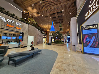
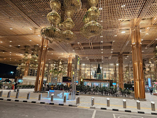
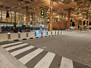
Bangalore International Airport (BIAL) Terminal 2 on 2023-08-20


Clicks from inside the Bangalore International Airport, Terminal 2 on 2023-08-20 evening. 
Photo courtesy: Adv Abhijit Sarkar 
* How India Travels 
* What Has Modi Done 
* Pathbreaking Initiatives By Modi Govt 
* Pathbreaking Initiatives By Bjp Govt

Hassan to Mangalore - Indian Roadie Preferred Route, Motoring Route, Driving Route, Route

Indian Roadie Preferred Route, Motoring Route, Driving Route, Route or 

Hassan to Mangalore
(Hassan_Mangalore), 
Belur to Mangalore 
(Belur_Mangalore) 

Hassan ---- Belur ---- Mudigere ---- Kottigehara ---- Charmadi Ghat (lots of twists and turns) ---- Ujire ---- Belthangadi ---- Madanthyar ---- Bantwal ---- Mangalore 

This route mainly traverses along the northern banks of Netravathi River. 

Distances: 
Hassan to Belur = 36 kms. 
Belur to Charmadi Ghat viewpoint = 60 kms. 
Charmadi Ghat to Mangalore = 92 kms. 

Search for following routes in reverse direction: 
Mangalore to Hassan 
(Mangalore_Hassan), 
Mangalore to Belur 
(Mangalore_Belur) 

* Motoring Routes of India (#MotoringRoutesOfIndia) is an initiative by Indian Roadie, India's most admired road travel and automotive forum for matured roadies.

Bangalore to Goa South + North - Indian Roadie Preferred Route

Indian Roadie Preferred Route, Motoring Route, Driving Route, Route for 

Bangalore to Goa 
(Bangalore_Goa): 

Bangalore - Tumkur (NH48) - Chitradurga - Davangere - Harihar - Ranebenur - Haveri bypass - after Bankapura Toll Plaza, exit NH48 towards Mundgod - Yellapur - Karwar (KA) - Canacona - Margao - Panjim - North Goa. 

Bangalore - Tumkur (NH48) - Chitradurga - Davangere - Harihar - Ranebenur - Haveri - Belgaum - Chorla Ghat - Sakhalium - Thivim - Mapusa.

Bangalore - Tumkur - Hubli - Kittur - Khanapur - Chorla Ghat - Panaji. 

Bangalore - Tumkur (NH48) - Chitradurga - Davangere - Harihar - Ranebenur - Haveri - Belgaum -  Sankeshwar - Gadinglaj - Ajra - Amboli ( expect traffic at waterfall) - Sawantiwadi - Mapusa - Candolim.

Belgaum - Chandgad - Dodamarg - Banda - Mapusa  

Belgaum - Chorla Ghat - Margao - Panjim. 

* Motoring Routes of India (#MotoringRoutesOfIndia) is an initiative by Indian Roadie, India's most admired road travel and automotive forum for matured roadies.

Mangalore to Bangalore - Indian Roadie Preferred Route in early Sept 2020 by Kiran Kakkattil


Kiran Kakkattil drove from Mangalore to Bangalore on 2018-09-02. 
While driving from Bangalore to Mangalore, Google Maps had showed the route via Charmady Ghat correctly as Shiradi Ghat was closed.
While returning, Google Maps showed him the Shiradi Ghat route and did not show Charmadi Ghat at all. Kiran took the Shiradi Ghat route and was stopped at the gate. He had to drive back for 90 kms and via Dharmasthala to reach Charmady (Charmadi) and lost 90 mins.
He has advised motorists travelling on that route to not just trust Gmaps and seek for confirmation from someone. 

* Motoring Routes of India (#MotoringRoutesOfIndia) is an initiative by Indian Roadie, India's most admired road travel and automotive forum for matured roadies.

Bangalore to Goa South - Indian Roadie Preferred Route, Motoring Route, Driving Route

Indian Roadie Preferred Route, Motoring Route, Driving Route for 

Bangalore to Goa (South) 
(Bangalore_Goa South): 

Bangalore - Tumkur (NH48) - Chitradurga - Davangere - Harihar - Ranebenur - Haveri (exit NH48, erstwhile number NH4) - Bankapur - Mundgod - Yellapur - Ankola (NH66, erstwhile number NH17) - Karwar - South Goa

Road condition (in mid August 2023): 
Bankapur to Yellapur: Some short stretches of manageable bad patches are there. 
Yellapur to Ankola: Good road. 

* Motoring Routes of India (#MotoringRoutesOfIndia) is an initiative by Indian Roadie, India's most admired road travel and automotive forum for matured roadies.

Hyderabad to Bhadrachalam - Indian Roadie Preferred Route, Motoring Route, Driving Route

Indian Roadie Preferred Route, Motoring Route, Best Intercity Driving Route, Best Route For Road Trip from 

Hyderabad to Bhadrachalam 
(Hyderabad_Bhadrachalam), 
Hyderabad to Khammam 
(Hyderabad_Khammam), 
Hyderabad to Palvancha 
(Hyderabad_Palvancha): 

Hyderabad (Peddaamberpet Toll Plaza, ORR Exit 11) (TS) ---- Drive East on NH65 upto Suryapet/ Suryapeta ---- Ramoji Film City on right of NH65 ---- Lakkaram ---- Panthangi Toll Plaza ---- Gundrampally ---- Chityala ---- Narketpalle/ Narketapalli (TS) (Kamineni Institute of Medical Sciences on right of NH65. ROR: NAM Expressway) ---- Pamanagundla ---- Nalgonda Cross Road (ROR: Nalgonda 14 kms) ---- Katangur ---- Nakrekal ---- Kethepally ---- Musi River Bridge ---- Suryapet (exit NH65 and start driving on NH365BB) ---- Khammam ---- Yellandu ---- Sudimalla ---- Tekulapally ---- Kothagudem ---- Govt Medical College, Kothagudem on right ---- Palwancha/ Palvancha ---- Kinnerasani River Bridge ---- Anjanapuram ---- Morampalle Banjar Ring Road ---- Bhadrachalam Public School + ITC Ltd (Paper Division) ---- Godavari River Bridge ---- Bhadrachalam (AP) 

Distances: 
Hyderabad (Peddaamberpet Toll Plaza, Outer Ring Road Exit 11, intersection with NH65) to Suryapet via NH65 = 115 kms. 
Suryapet to Khammam via NH365BB = 65 kms.  
Khammam to Yellandu = 47 kms. 
Yellandu to Kothagudem = 35 kms. 
Kothagudem to Bhadrachalam = 40 kms. 

* Telangana Trails 
* Andhra Pradesh Trails 

Note: These are user generated best routes. 

Abbreviations in use in Motoring Routes Of India, Indian Roadie Preferred Route, Motoring Route, Driving Route:
RA = Road Ahead.
ROR = Road on Right.
ROL = Road on Left.
NH = National Highway.
SH = State Highway.
NE = National Expressway.  

P.S: 
- Offline Driving Route In One Page 
- Best Intercity Driving Routes 
- Skip Online Navigation Maps 
- User Generated Best Routes 


* Motoring Routes of India, Best Route For Road Trip are initiatives by Indian Roadie (India's most admired road travel and automotive forum for matured roadies) and Marketingpundit. 

P.S: Search thousands of accurate and best route options for road trips throughout India, Nepal, Bhutan in: 


Bangalore to Mangalore via Charmadi Ghat - Indian Roadie Preferred Route, Motoring Route, Driving Route, Best Route For Road Trip

Best Route For Road Trip, Indian Roadie Preferred Route, Motoring Route, Driving Route from 

Bangalore to Mangalore (via. Charmadi Ghat) 
(Bangalore_Mangalore): 

Bangalore (Bidhan Soudha) ---- Neelamangala ---- Junction of Tumkur Road ---- Solur ---- Kunigal junction bridge ---- Nelligere ---- Bellur Cross ---- Adichunchanagiri Hospital and Research (on right) ---- Hirisave (police station) ---- Settyhalli ---- Manjunatha Petroleum HPCL (on right) ---- Channarayapatna (CR Patna) ----  Hassan (Rockwell International School) ---- Karekere ---- Shanthigrama ---- Tolallu ---- Charmadi Ghat (Attigere) ---- Charmadi Ghat (view point) ---- Netravathi River Bridge ---- Ujire Circle ---- Bantwal (Circle near Somayaji Hospital) ---- Bantwal Toll Plaza (Thumbs vented dam on left) ---- Pudu ---- Mangalore (Kannur post office) ---- Mangalore (Horticulture Park on right) ---- Mangalore (Nanthoor Junction/ intersection with NH66) ---- Proceed on NH66 ---- Mangalore (KPT Junction on NH66/ Road to Airport forks off on right) ---- Mangalore (Kuntikana Junction on NH66, old NH17).

Distances: 
Bangalore to Charmadi Ghat (view point) = 280 kms/ 5 hrs 30 mins. 
Charmadi Ghat (view point) to Mangalore (Kuntikana Junction) = 93 kms/ 2 hrs 30 mins. 

Bangalore (Bidhan Soudha Metro Station) to Neelamangala = 30 kms. 
Neelamangala to Kunigal = 44 kms. 
Kunigal to Bellur Cross = 34 kms. 
Bellur Cross to Hirisave = 19 kms. 
Hirisave to CR Patna = 20 kms. 
CR Patna to Hassan = 37 kms. 
Hassan to Charmadi Ghat (view point) = 96 kms. 
Charmadi Ghat (view point) to Ujire Circle = 28 kms/ 45 mins.
Ujire Circle - Bantwal (Circle near Somayaji Hospital) = 42 kms/ 1 hr.
Bantwal (Circle near Somayaji Hospital) - Mangalore (Kuntikana Junction) = 23 kms/ 30 mins.

Road condition:  (in August 2023)
Road is good and quite scenic 

* Karnataka Trails 

Note: These are user generated best routes. 

Abbreviations in use in Motoring Routes Of India, Indian Roadie Preferred Route, Motoring Route, Driving Route:
RA = Road Ahead.
ROR = Road on Right.
ROL = Road on Left.
NH = National Highway.
SH = State Highway.
NE = National Expressway.  

P.S: 
- Skip Online Navigation Maps 
Offline Driving Route In One Page 
- Skip Google Maps 
- User Generated Best Routes 


* Motoring Routes Of India, Best Route For Road Trip are initiatives by Indian Roadie (India's most admired road travel and automotive forum for matured roadies) and Marketingpundit. 

P.S: Search thousands of accurate and best route options for road trips throughout India, Nepal, Bhutan in: 

Hyderabad to Chitrakoot Falls (CG) by Supratik Bose in August 2023


Road trip from Hyderabad to Bastar in end August 2023 by Supratik Bose. 
Car driven: Maruti Alto K10 

Here is an update on the route and road condition. 

Hyderabad - Narketpally - Suryapet - Khammam: Excellent with a special mention for the 6 lane expressway leading out to Khammam. 

Khammam - Yellandu - Tekulapally - Kothagudem - Bhadrachalam: Mostly 2 lane undivided, smooth surface. Was charmed by the rustic beauty of Andhra villages by the hills awash with monsoon greenery. Could give Coorg a run for its money. 

Dornapal - Sukma: The infamous stretch. Concrete road with good surface. You will see CRPF camps every 1 km. No fuel pumps or eateries on this stretch with little mostly local traffic. Didn't feel any safety issues. We crossed at noon. 

Sukma town: We ate a veg thali at a decent eatery with a AC family section. You can also tank up at Sukma. Looked like any other small town in India, perhaps a little less busy. 

Sukma - Jheerang ghati - Darbha - Kanger valley National Park - Narayanpal (Bastar):  The road deteriorates around 20 kms after Sukma as you reach the base of the ghat climb. Progress is slow, difficult to exceed 30 kmph but nature is breathtaking. Bigger vehicles should not find it too difficult. Spent some time at the memorial at Darbha where a convoy was ambushed in 2013 and 25 people were killed. The last stretch of Chitrakote road is narrow but excellent. We made it to our stay (STF camp resort) at 8 PM driving in blinding rain. 

RETURN LEG 
Farsapal - Bhairamgarh (Dantewada Geedam road) - Bijapur - Bhopalpatnam: Excellent SH with little traffic. 

Bhopalpatnam - Tarlaguda - TS border (NH 163):  You will be floored if you love driving. Excellent freshly laid undivided 2 way with banking and almost no traffic. Best 2 lane highway stretch I have seen so far and my car has been to 19 states + a neghbouring country. They have used the bitumen which gives the surface a pink hue, so you can imagine the quality of construction. Forgot to take pictures as I was so absorbed in the drive. Would love to come back on a bike. Beware of local livestock though. 

Bogotha waterfalls - Eturanagram - Tadvai - Mulugu: Excellent 2 lane passing through the reserve forest.
Post this the road surface really deteriorates and I was tested as it was after 7 PM when we hit this stretch. There is also a small bridge with the river flowing over it, so you get a taste of Ladakh style water crossing also. Road improves with 20 odd kms to go before Warangal. Tolled 4 lane roads after that all the way to Hyderabad. 

Bastar is beautiful, beyond my imagination. Rolling green hills with sleepy hamlets here and there. All the waterfalls that you would want to see with many accessible. Perhaps one of the last regions which has not been exploited yet, as we saw mostly local tourists. Saw many checkposts and security personnel with automatic weapons. Didn't sense any safety issues but use your discretion as the region still sees conflict. Local drivers drive fast as roads, even internal ones are good and hardly have speedbreakers, even when you come across villages. Watch out for livestock. 

Distances: 
Hyderabad (Peddaamberpet Toll Plaza, Outer Ring Road Exit 11) to Suryapet via NH65 = 115 kms. 
Suryapet to Khammam via NH365BB = 65 kms.  
Khammam to Yellandu = 47 kms. 
Yellandu to Kothagudem =  35 kms. 
Kothagudem to Bhadrachalam = 

Thursday, 24 August 2023

Somnath to SOU Kevadiya - Indian Roadie Preferred Route, Motoring Route

Indian Roadie Preferred Route, Motoring Route, Driving Route for road trip from 

Somnath to SOU Kevadiya (Statue of Unity)
(Somnath_SOU): 

Option 1: 
Somnath - Gadu - Keshod - Junagadh - Vadal - Jetalsar - Pithadia - Chordi - Bhojpara - Pipaliya - Shapar (Atul Auto Ltd, Duroply Industries Ltd on left) - Lodhika (Shell Filling Station on right) - Rajkot - Bagodara - Tarapur - Karamsad - Aanklav - Vadodara - Dabhoi - Statue Of Unity / Kevadiya. 

Short route with very good road condition, almost entirely 4 lane highway. 

Option 2: 
Somnath - Junagadh - Rajkot - Bagodara - Tarapur - Karamsad - Vasad - Vadodara - Dabhoi - SOU / Kevadiya. 

While driving from Vasad towards Vadodara, motorists have to pay toll of ₹175. 
Short route with very good road condition, almost entirely 4 lane highway. 

Option 3: 
Somnath - Junagadh - Rajkot - Ahmedabad - Vadodara - SOU / Kevadiya. 

Longer route with very good road condition, good amenities by the roadside, entirely 4 lane highway. 

Distances: 
Somnath to Junagadh = 90 kms. 
Junagadh to Rajkot = 100 kms. 
Rajkot to Bagodara =  kms. 

India ISROcking


Indian Roadie and Bengal Roadie celebrates the landing of Chandrayaan 3 on moon on 2023-08-23 evening (IST) by wholeheartedly congratulating the scientists at ISRO. 

Shifting of Tata Nano plant from Singur to Sanand


Tuesday, 22 August 2023

IR GTG on 2023-08-21 at Goutam's (opposite, City Centre 1) with Abhijit Sarkar


After completion of a very important meeting on Monday 2023-08-21 evening, ndian Roadie Abhijit Sarkar and myself developed the usual pangs of hunger. 
We drove to Goutam's, opposite City Centre 1, Salt Lake for yummy Chicken Rolls and Hot Chocolates in baked clay bhaands. 
These get-togethers with true well wishers keeps me motivated to roll out back of the screen innovative projects one after the other. 
* Indian Roadie GTG